Unconquered Country
Journey to the Nemiah Aboriginal Wilderness Preserve
I had mythologized it, I had romanticized it, I had wanted to visit for almost ten years.
In a province filled with remote and rugged places, the Nemiah Valley remains distinct. It is a startlingly beautiful landscape, full of wild horses and grizzly bears, jagged peaks and turquoise lakes and sprawling golden pasture. But what really sets Nemiah apart is its history — in 1864, at the height of the Cariboo Gold Rush, the Xeni Gwet'in people of the Tsilhqot'in First Nation successfully resisted European incursion into their territory. What would later be called the Chilcotin War was one of the few instances of armed conflict in the settling of Canada, and one of the very few where it can be said the First Nations won. The Nemiah Valley and Chilko Lake would remain off the grid for another 100 years, the people free to continue their traditional lifestyle without interference from government or corporations well into the twentieth century. It wasn't until the mid 1970s that road access was finally built, and once again the Xeni Gwet'in fought hard for their land — this time to protect it for everyone and designate it as a provincial park.
It's a beautiful, evocative country. And darned if we weren't excited to see it with our buds Adam and Adriana Sinke.
BEFORE YOU GO


THE INTERIOR
We are drawn to differences. Living in Vancouver we've gotten used to the perpetual greens, thick impenetrable forests, dark cloud-shrouded hills, and endless damp. We love it here on the wet West Coast, but we do crave an escape now and again. We yearn for expansive landscapes, for open rolling rangeland, for arid deserts and golden plateaus. And luckily enough just a few hours east, through the stunning Fraser Canyon or over the breathtaking Coquihalla, beyond the rain-shadow of the Coast Mountains, we can find just that.
The difference is striking. While it's geographical proximity is almost negligible in a car, the act of arriving feels like a whole other thing. Where the coast is a dense dark green of wet hemlocks and ferns and briny ocean air, the interior plateau is a land of open pasture, of deserts and dunes, sages and scrub, canyons and cowboys, ghost towns and gold rushes, and lots and lots of pine. There is a feeling of almost impossible scale. It is a land of seemingly illimitable resources, of timber and minerals and agriculture, of pickup trucks and clearcuts and once mighty boom towns. And surrounding it all, waiting, is wilderness.

We drove north out of Vancouver on the Sea to Sky Highway towards Seton and Lillooet and the Fraser Canyon. We camped out on the side of the highway that first night, on a thick bed of dry pine needles and sharp pinecones. What looks like unending and unknowable forest from the highway is in fact crisscrossed by countless forest service roads, and if your car and your schedule permits there are miles and miles and days and days of back roads to explore. Adam had a mind to do just that, with a route planned out primarily through dirt roads and backcountry, testing what the overpacked and drooping Corolla could handle.
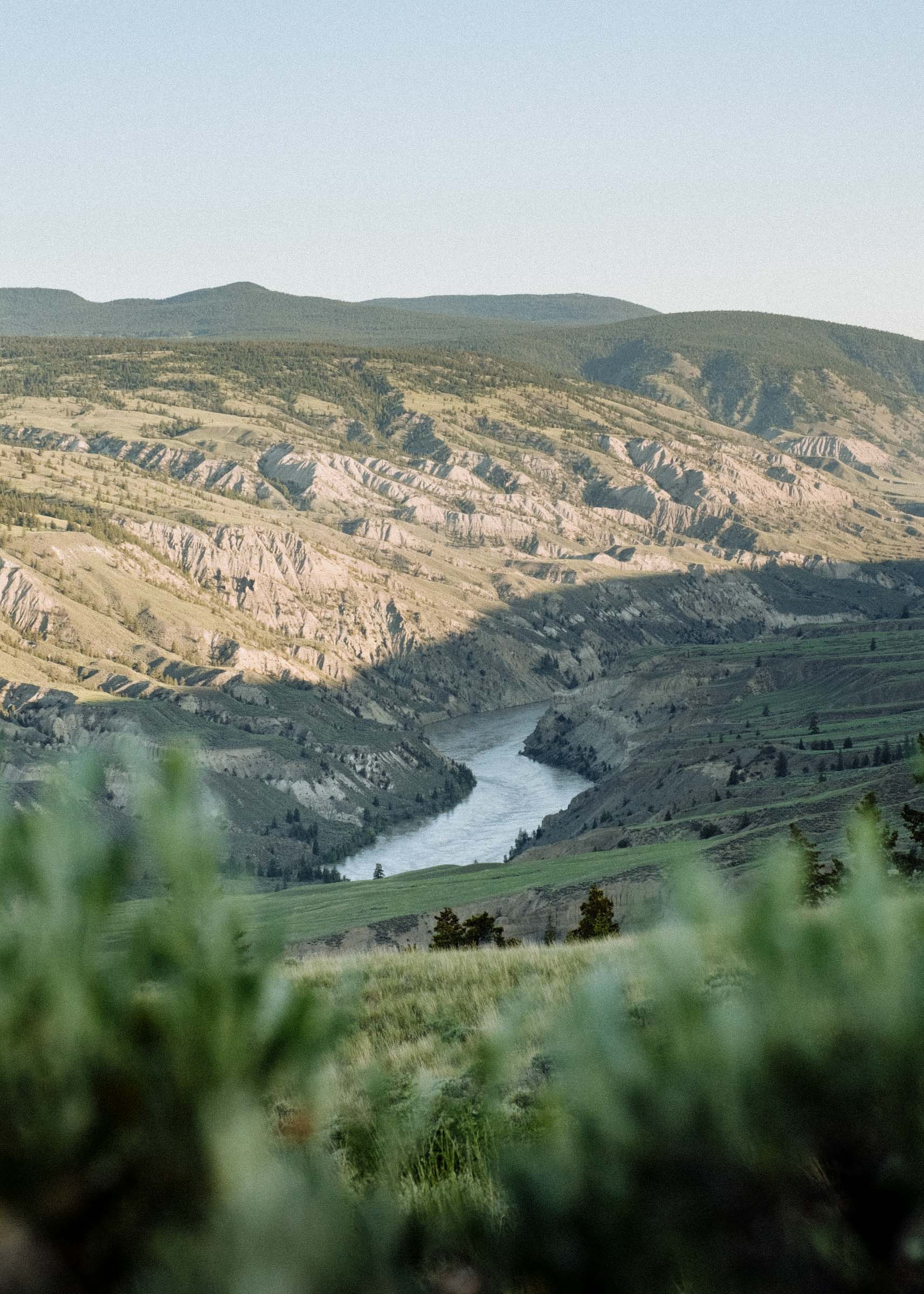
One of the places we were most keen to visit was Farwell Canyon just a little ways off the Bella Coola highway on a well-serviced and well-travelled gravel road. This is supremely beautiful country and totally unlike anything on the coast. There are hoodoos and dunes and dry rolling grassland and bighorn sheep overlooking a meandering milky blue Chilcotin River. We parked the car and walked into the dry brittle sage and looked out over the country. The land was so open, so spare, it was hard not to imagine riding a horse across it. We crossed a bridge spanning the canyon, quietly watching people scoop huge flopping salmon out of the grey blue waters with nothing but hand-held nets. It is a harsh but truly invigorating country.
We made camp in a horseshoe bend of the rumbling river, drank deep from the ice-cold milky roar, and managed to only spill half of our dinner on the ground. We went to bed under a star-laden sky, the nip of early autumn hovering at the edges of camp.


BC has a fascinating history of pioneers and prospectors but the way we tell it it can sometimes sound as though European settlement was an inevitability. Chilko Lake and the Nemiah Valley, for over a hundred years and well into the twentieth century, proved an exception.
BC was slow to be settled. Over two centuries after contact only a handful of fur trading outposts had been established, the rough landscape hindering most explorations. It wasn't until 1858, with the discovery of gold in the Fraser Canyon, that whites began streaming in. Cities were born almost overnight, and tensions between the rowdy newcomers and the local First Nations began mounting — and when more gold was found in the Cariboo that tension spread north. Accessing the gold fields was an arduous feat across mountain ranges and raging rivers, through canyons and desert. Prospectors began looking for a more direct route, and one proposed route went through Tsilhqot'in land.
By many accounts the Tsilhqot'in First Nations had long been content in their isolation. While the neighbouring Nations were trading furs with the early Europeans, it is reported that the Tsilhqot'ins kept largely to themselves. When Alfred Waddington, wanting to reduce travel time to the Cariboo gold fields from 37 days to 22, began surveying a road from Bute Inlet through Nemiah without prior consent or diplomacy, the Tsilhqot'ins were no doubt alarmed but they weren't initially unhelpful, and some even signed on as labourers.
But two years into construction the Tsilhqot'in grievances reached a turning point. The constant threat of new diseases, of abuse at the hands of the white workers, of desecration of graves and sacred watering sites compounded with genuine concerns over land title, and the Tsilhqot'ins had had enough. Tribal leaders got together and sent Lhats'asʔin (Klatsassin), the war chief of the Xeni Gwet'in Tsilhqot'ins, to declare war on the intruders and he attacked several work parties, killing 19 men and driving out many others, going so far as to accompany them to Bella Coola to make sure they left on boats.
Provincial authorities viewed these acts as murder and sent two groups of soldiers north, both eventually retreating due to ambushes and difficult terrain. The Crown then lured the warriors out with promises of amnesty and peace talks. The Tsilhqot'ins, believing they would be forging an agreement between nations on the order of that with French Canada, came out dressed in French uniforms not unlike Montcalm on the Plains of Abraham. But they were deceived — the Province ambushed them and brought five of the Tsilhqot'in men, including Lhats'asʔin, to trial.
In defence of their actions, Lhats'asʔin said they weren't committing murder, they were waging war. They weren't criminals, they were official representatives of an autonomous and previously uncontacted and untreatied nation resisting the colonization of their territory. But Judge Begbie disagreed and sentenced them to public hanging.
Despite these deceptions and the ultimate decimation of settler-introduced smallpox (upwards of 70% of the Tsilhqot'in population died), the Province and the forces of colonization backed off. The Nemiah region and the Xeni Gwet'in tribe would remain largely undisturbed from European incursion for another 100 years until the government pushed a road through in 1973. Just 200 miles northwest of Vancouver in a resource-dependent province criss-crossed with logging roads and clearcuts, the Nemiah caretaker region still feels like it's truly remote.
And in October 2014, 150 years after the Chilcotin War and 1 month after our visit, the Province finally exonerated the Tsilhqot'in chiefs of any crime or wrongdoing. It may be that reconciliation is finally be possible.


Even with road access Nemiah is still kinda off the map. You turn off the main highway towards Bella Coola, then again at a two-building town called Hanceville and pass through the Yunesit'in (Stone) Reserve, then miles and miles of dirt road through thick forest and dirty clearcuts punctuated by occasional clearings, sites of old homesteads and ranchland, and rare views of snow-domed Tsi'lo?s (Mt Tatlow).
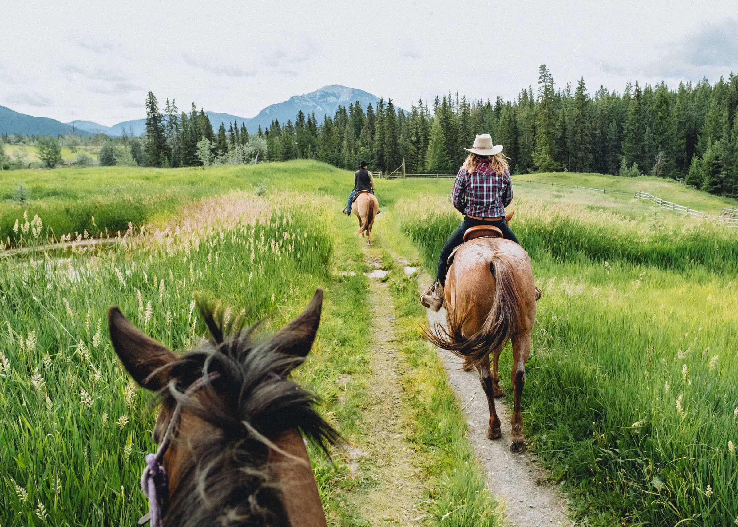
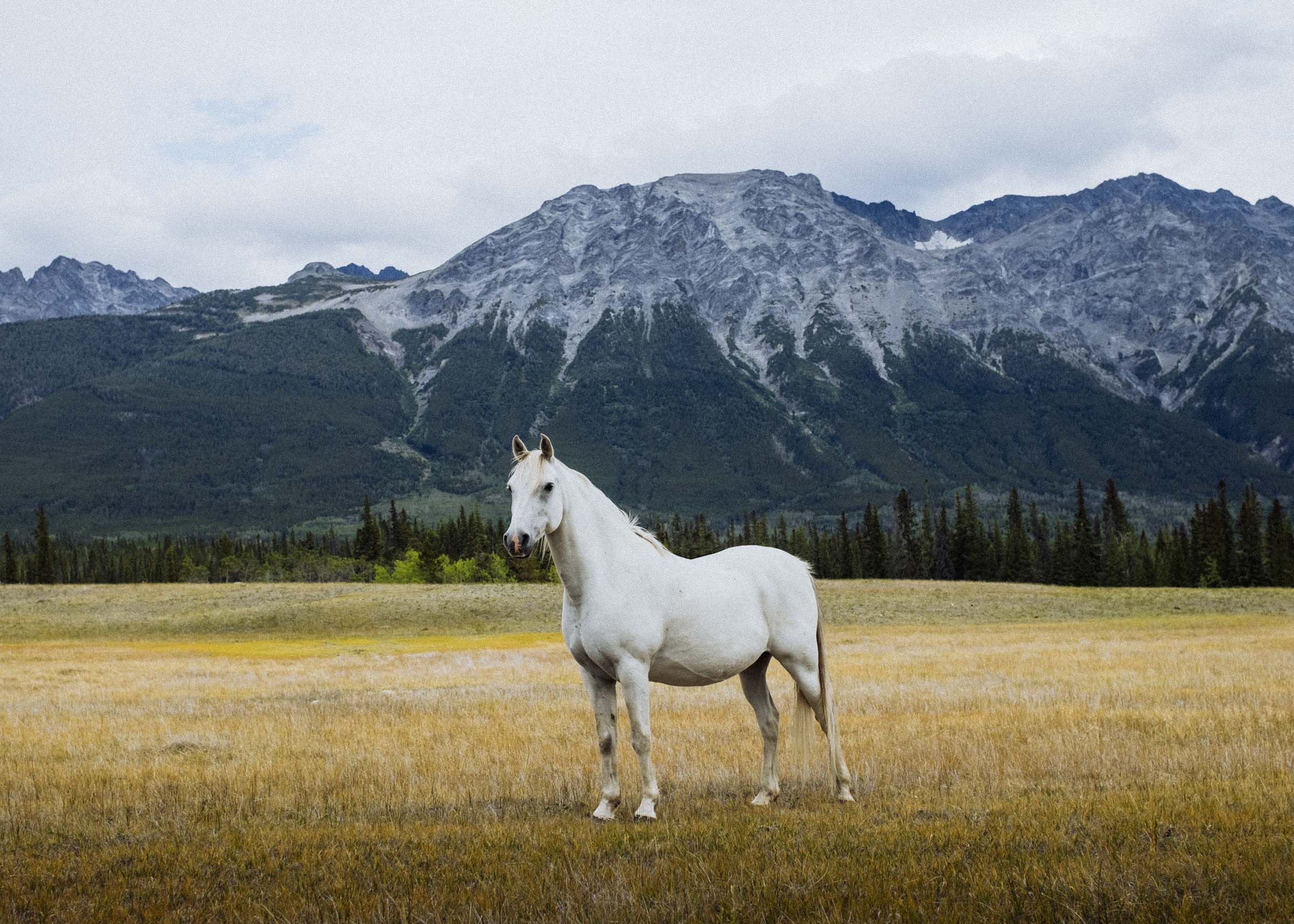
The first sign you've made it to Nemiah is the old log church and the long view down Konni Lake. The second sign is the sudden appearance of free-roaming horses.
There are an estimated 800–1000 wild or free-roaming horses in the Chilcotin, and about 200 truly wild and genetically distinct horses in the Brittany Triangle area, from where the Nemiah people have caught and trained them for centuries. These horses have been crucial to the development of the Tsilhqot'in's unique ranching culture. No one knows exactly how or when the horses first arrived but historical and DNA evidence suggest they made their way here well before the first European explorers did.
The truly wild horses are skittish and elusive, but the area is full of free-roaming horses who, having been handled by people at some point, are more curious and aloof. They will probably run away if you approach, but generally not before you've gotten a good glimpse.


After Konni Lake comes the little settlement of Nemiah, mostly ranches and cabins and more horses, and then left onto a rough road to Tsi'lo?s Provincial Park. Our car kept bottoming out so we left it and carried our stuff the rest of the way in. At the end of the road sits the startlingly blue Chilko Lake, the largest high-elevation lake in the province and by all accounts one of the windiest. It's almost too big, really — strong winds whip up constantly, and the saw-toothed peaks feel impalpable and far away.
It is wild country, and with wild country comes wildlife. Grizzly bears are common, sometimes so common that sections of the park have to be closed for parts of the year. We didn't see any bears ourselves but there was one about — we came across the telltale sign of a fresh half-eaten salmon. We made sure to make plenty of noise while exploring the lakshore and to store all the licorice safely in our bellies.


Just north of the campground is a ritual site and a newly constructed pit house. It was very large and open inside, and we sat in silence for a little while, not sure if we were trespassing or if it was built expressly for visitors. After a bit we went back to the lake for an ice cold dip. It's a tough life.


Our original plan was to tramp around the mountains for a day but when we arrived in the park we found out that the Xeni Gwet'in have requested people not climb Tsi'lo?s or the neighbouring peaks and BC Parks imposes the no-hiking rules in its land-use guidelines. So ya, we thought we had better not. While there didn't seem to be anyone around to enforce it, given the area's history it hardly seemed appropriate to just drive up and ignore that. We were just visitors here. There are plenty of other hills to climb.
So decided to get a head start on the long drive back to the highway, spend a night in the Hot Dog Field, and explore more of the Junction Sheep Range the following day.


JUNCTION SHEEP RANGE
I like to think that the Junction Sheep Range is a tidy summation of all the best the Chilcotin has to offer. It's the kind of country we Vancouverites spend all winter dreaming about: golden grass and dry draws, copses of aspen and scraggly ponderosa, all perched above the picturesque Chilko River valley.
At the southern tip of the park is the eponymous confluence of the Chilko and Fraser Rivers. I'm certain it's beautiful and everything you could ever want from a landscape but you'd need a long day's hike or 4x4 with good clearance to get out to the viewpoint so we never got to verify that. We did see some of the resident California bighorn sheep though! The Range has a population of about 500 or so, and they're reason the park exists.
It had rained a fair bit the night before and the fields were wet. We tramped around for a couple hours and got the soggiest feet, our socks pin-cushioned with countless sharp grass seeds. Good times.


HOMEWARD
Going home is of course everyone's least favourite part of any trip, but luckily we were spreading the drive out over two days. We hopped onto the highway and drove to Lac La Hache then into the bush, camping on little Lake Helena in country so flat we thought it could have been Ontario. We watched the sun set over the lake while listening to the skin-tingling sound of the lonely loon call, lit a campfire to ward off the September chills, ate some popcorn, and waited for the stars to come out one by one.
Then onward, along slow dirt roads to Meadow Lake and Beaverdam Lake and lake after lake after lake. There are a lot of lakes! And a lot of forest. And there, on the last wild leg of the last day of our trip, we finally saw our bear, looking for all the world like a furry four-legged hole in the landscape. We pulled back onto the highway and back into traffic and back onto roads that were paved and blessedly silent. We stopped for burgers and fries and ice cream at Cache Creek's iconic Hungry Herbies, then enjoyed one last lingering swim at Lake of the Woods before the unrelenting freeway whisked us through the Fraser Valley back to the city and back to our homes.